EFTAS Fernerkundung Technologietransfer GmbH
EFTAS.GeoIT
Precisely for your world

Quality &
Individuality
from Münster
since 1988

GEOINFORMATION AND IT-SERVICES.
ACROSS ALL FIELDS.

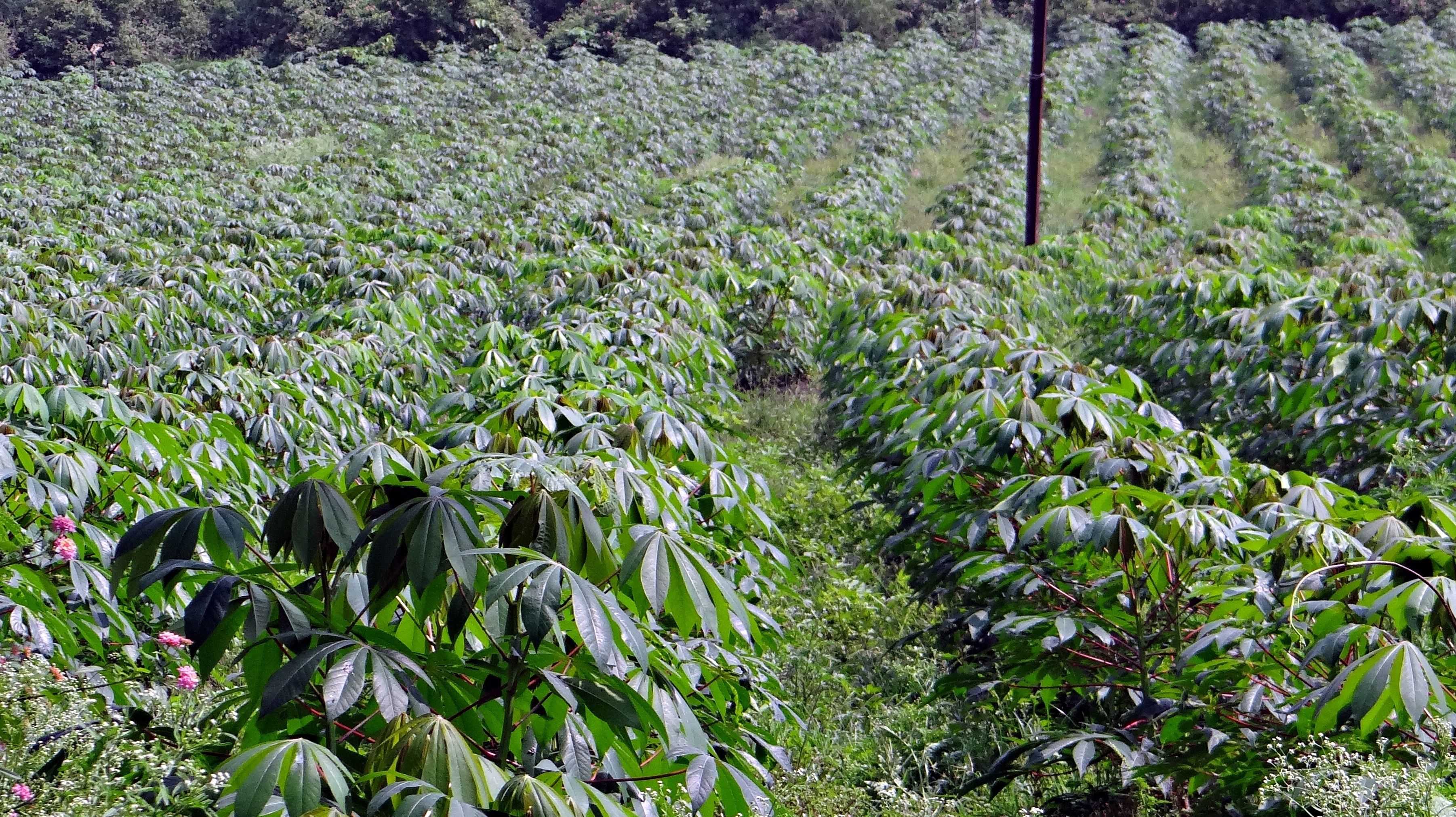
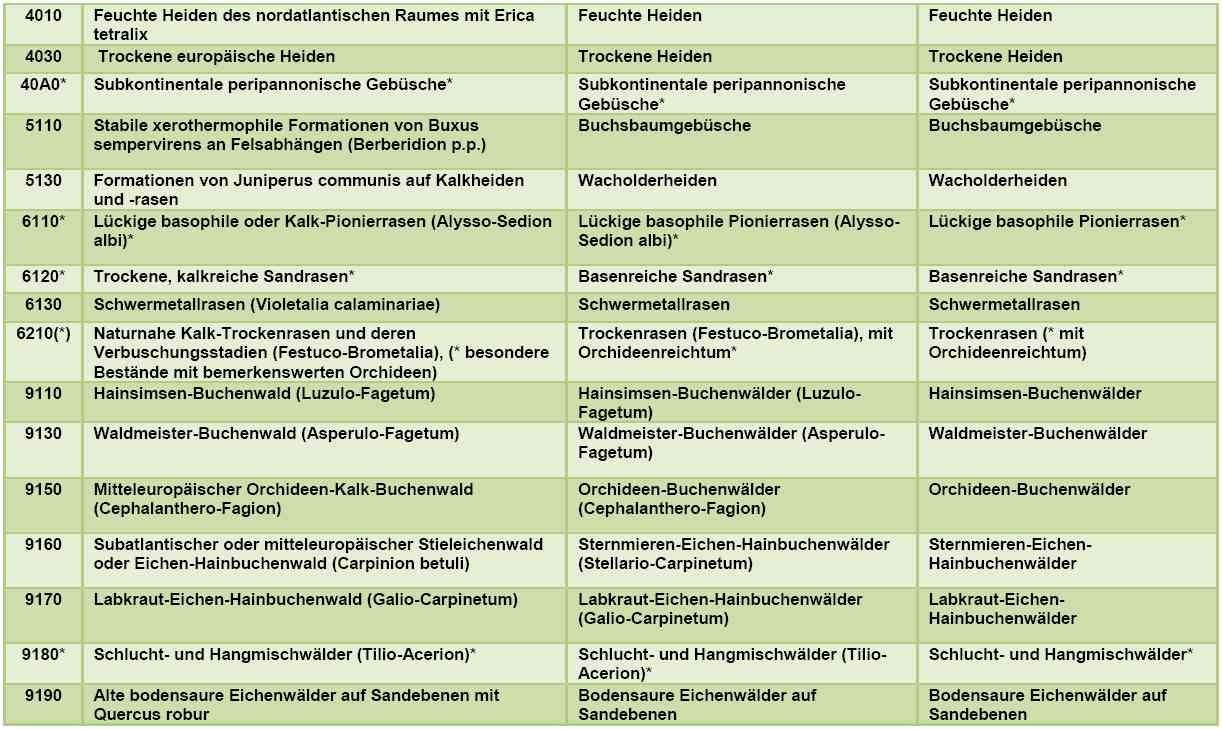
Every industry sector, division, market or business area is a world of its own. Common to almost all of them is the use of geoinformation. Many fields of application use geodata in the form of digital cartographic information as a knowledge base. Examples include aerial and satellite imagery, maps of land use/land cover or environmental inventories.

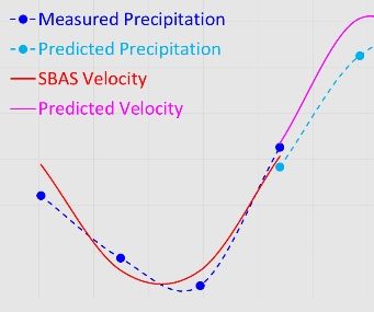
Within many fields of application, the benefits of using geoinformation and GeoIT are obvious. What is grown where? Where is the best navigation route? Where can we find resources? Less apparent is the potential of GeoIT as location intelligence within IT-based business and administration processes. The spatial data form a valuable parameter and help to enable new conclusions to be drawn from an existing knowledge base.

As geoinformation experts, we are prepared to help you with your field of application, be it knowledge enhancement or the expansion of your IT processes.

Take inspiration from the variety of application domains of GeoIT and geoinformation and contact us!

Tourism

Knowing where to go is always a good thing. Internet and navigation systems are increasingly being used for recreational purposes and for exploring different routes and places of interest. Our range of geoinformation and GeoIT systems offers tourist regions the chance to present themselves via digital media in a more attractive way and also to increase their visibility.

This provides the perfect means of marketing places of interest, hiking, cycling and riding paths or accommodation and restaurants – with information portal, app and database solutions.

  • We develop tourist map portals with a routing engine.
  • We develop scalable apps for thematic navigation.
  • We create mobile city and regional guides.
  • We collect, compile and update your data.

Something for careerists.

Travel guide App „Platzhirsch“ for a modern tourism marketing including crowdsourcing.

learn more
Travel guide App „Platzhirsch“ for a modern tourism marketing including crowdsourcing.

Know your local area.

Visitor information system and management tool „Tourenplaner Münsterland“.

learn more
Visitor information system and management tool „Tourenplaner Münsterland“.

Agriculture and forestry

Forests, fields and meadows shape large areas of our landscape. In Germany, these areas take up more than 80% of the country. The expectations of modern agriculture and forestry are complex. Are we aiming to maximise yield or for ecological farming? Do we want to harmonise both? The European Union stipulates fundamental rules on how to deal with these questions.

Up-to-date geoinformation and GeoIT systems deliver data quickly and on a large scale. Farmers and foresters receive data for efficient and ecological farming, while the administrative sector receives data for planning and control purposes.

  • We support agriculture and forestry administration – worldwide.
  • We provide delegated tasks for IACS-related services, including subsidy control (InVeKoS).
  • We undertake evaluations and preservations of evidence and monitor site development.
  • We prepare forecasts of crop yield and crop damage.
  • We integrate European regulations as part of common agricultural reform.
  • We map forests and agricultural areas with remote sensing technologies and in the field.
  • We support decision-making in precision farming.
  • We implement agricultural statistics systems.
  • We implement specific information systems.

Try our EFTAS Crop Analyzer! The prototype web application allows the free use of an artificial neural network to determine agricultural crop types with photos from the field.

AgroSurvey.

ArcGIS extension for the control of agricultural subsidies.

learn more
ArcGIS extension for the control of agricultural subsidies.

Breakage and throw after the storm.

Detection of storm-damaged timber with CIR aerial photographs.

learn more
Detection of storm-damaged timber with CIR aerial photographs.

Malawi is eager to know.

Yield forecast with field survey and remote sensing.

learn more
Yield forecast with field survey and remote sensing.

Environment, nature and landscape

Land is a highly valuable asset and very much in demand. It is important in many ways: food, energy, development, ecology, landscape and recreation. It is a challenge to bring together all these competing demands without compromising nature. A wide range of laws and European reporting obligations define the relevant guidelines.

Up-to-date geoinformation and GeoIT systems document the state of nature and environment. This knowledge forms the basis for planning and legal regulations. This knowledge based on geoinformation and GeoIT systems also helps to communicate the importance of nature and environment as a foundation of life worth protecting.

  • We map nature and the environment by remote sensing and on site.
  • We provide data for reporting requirements and regulations such as the EU-FFH-, Waste Framework- or Water Framework Directive and compensation area assessments.
  • We detect changes in vegetation and its vitality.
  • We support the monitoring of water bodies to ensure water quality and to detect substance inputs.
  • We monitor near-surface runoff regimes, hydrological conditions, and subsurface uplift and subsidence.
  • We record land sealing and changes in civil engineering.
  • We help to monitor slope stability, terrain edges and other sensitive areas.

Precipitation causes soil movement.

ISPRS paper on predictive model with ADInSAR.

learn more
ISPRS paper on predictive model with ADInSAR.

WaCoDiS - New Copernicus service.

Cooperation project for water monitoring.

learn more
WACODIS - NEW COPERNICUS SERVICE.

Every 6 years!

Remote sensing based field data for an efficient FFH monitoring.

learn more
Remote sensing based field data for an efficient FFH monitoring.

Energy and Mining

Sustainable energy production and use of resources is – without exaggeration – essential to our existence. The spatial reference is obvious. Geoinformation and GeoIT are integral components of green technology.

It is a matter of resource efficiency and environmental protection. Geoinformation and GeoIT systems support the mining process, from the exploitation of new deposits to the rehabilitation of former mining areas.

Soil moving monitoring using globally available radar data from various sensors is one of our core competencies in this area.

It is used, for example, in the monitoring of infrastructures such as pipelines, tailings or cavern storage facilities, where soil movements over a large area must be detected and transmitted in a closely timed manner.

The most immediate possible detection of even the slightest ground movements also helps to counter potential risks, e.g. mining damage, as early as possible and thus as effectively as possible.

For large-scale monitoring of ground motion, we use methods of satellite-based radar interferometry and combine this technology in a customized way with the evaluation of further data such as optical sensor information or terrestrial campaigns.

  • We support exploration planning and produce cluster and distribution maps.
  • We provide information on tectonic and structural geology.
  • We assist in all areas of a mining cycle from exploration to production to closure and renaturation also long term monitoring in post mining.
  • We provide monitoring of soil movements in the area of mining impacts and monitor all types of infrastructure such as plant and equipment safety, structure and route inspections.
  • We support condition monitoring of pipelines and cavern storage facilities through ground motion monitoring and vegetation analysis.
  • We provide support for tailings basin monitoring through the use of radar and optical data.
  • We carry out remote sensing-based preservation of evidence.

Ground Movements.

Cost-efficient monitoring with AI and customized data.

Cost-efficient monitoring with AI and customized data.

Efficient monitoring of cavern storage facilities.

KaMonSys integrates satellite and copter data.

learn more
Efficient monitoring of cavern storage facilities.

Infrastructure and mobility

Technologies involved in city and traffic systems are becoming more intelligent. Artificial intelligence is based on modelled rules that help information-processing systems to derive findings automatically from a knowledge base. SMART is the term of the moment for those processes and systems. SMART City and SMART Mobility both require digital knowledge bases. These are based on geoinformation such as the land register „Amtliche Basiskarte (ABK)” or 3D city models.

Besides the classic applications of waste water fee splitting, planning of transponder networks for wireless services or traffic management, SMART applications based on geoinformation will establish themselves. They include analyses and processes that interconnect different urban subsystems through a common georeferenced map system. Building Information Modelling (BIM) is one such example. It connects areas such as infrastructure planning, planning of services or SMART Home by attaching all relevant information to the virtual building model.

  • We offer land register services.
  • We conduct mapping of urban utilisation, sealing and changes.
  • We develop 3D city models using photogrammetry.
  • We create urban inventories.
  • We develop SMART applications.

Taking new paths.

Geoinformation for traffic infrastructure planning.

learn more
Geoinformation for traffic infrastructure planning.

Safety

Authorities, and organisations with responsibilities involving safety, need completely up-to-date information and the best possible overview of the situation when they are deployed. This is for the purposes of prevention, investigation and monitoring on site so as to restore order to the situation in hand.

Our support for the command loop involves integrating aerial and satellite imagery and implementing geo IT components to incorporate municipal maps.

  • We create digital situation report systems and incident logs.
  • We offer advice on incorporating and using map data.
  • We prepare basic map information for your operational area as well as journey time analyses.
  • We conduct research for your safety.

Fire (danger) watcher for associated green.

Cloud and AI-based Copernicus service CCFireSense. 

learn more
Cloud and AI-based Copernicus service CCFireSense.